
Joshua Dill: Please tell us about your background and how you came to be in your position as state engineer.
Pat Tyrrell: I started out with two engineering degrees from the University of Wyoming, the second one being a master’s in civil engineering with an emphasis on water resources. Upon receiving that, I went to work for a Western water-focused consulting business in Laramie for about 8 years. I then moved to Minnesota for 2 years to see more of the world and worked for a consulting firm there. I then moved back to Wyoming and worked in regulatory affairs for the Black Thunder coal mine for a little over 4 years. After that, I returned to consulting here in Cheyenne. I applied for and was appointed to the position of state engineer in early 2001 and continued in that position until April 1, 2019. As state engineer, I was Wyoming’s compact commissioner on three interstate compact commissions—the Upper Colorado River Commission, the Yellowstone River Commission, and the Bear River Commission. I also represented Wyoming on the North Platte Decree Committee. I represented Wyoming on the Western States Water Council and Colorado River Salinity Control Forum and its advisory council. I held, and continue to hold, two positions related to the Colorado River: In addition to being commissioner on the Upper Colorado River Commission, I was also named, first by Governor Freudenthal, the Wyoming governor’s representative to the seven basin states.
Joshua Dill: Would you give a basic overview of why the DCP is needed?
Pat Tyrrell: We have developed demands on the river that are larger than current runoff and what years of evaluation have revealed is the river’s supply. In particular, while none of the upper basin states has fully used its apportionment under the 1922 and 1948 compacts, we do know that there is a structural imbalance in the lower basin where demand exceeds supply by about 1.2 million acre-feet a year on average. That, coupled with drought, is the reason the DCP is needed. In the last 12 years, we have followed the 2007 interim guidelines on shortage and coordinated reservoir operations, which were designed to get us through what looked to be a pretty tough period back in 2005. The drought we’ve seen since then has demonstrated that those guidelines weren’t strong enough. What we’re doing with the DCP is twofold: trying to cure overuse in the lower basin when Lake Mead is at low elevations and to protect the upper basin so that we can continue to meet our compact obligations at Lees Ferry until those 2007 interim guidelines are renegotiated, which should occur by the end of 2026. The DCP is a, therefore, a bridge to get us from the 2007 interim guidelines, which were not quite robust enough, through their renegotiation, which starts next year and goes through 2026. The experience that we’re gaining now will inform what the guidelines look like after that time.
Joshua Dill: Why were the 2007 guidelines ultimately insufficient? Did the weather or climate develop in unexpected ways?
Pat Tyrrell: All I can say is that they were prepared with the level of knowledge we had at the time. Also, understand that what we developed was what seven states could agree to. We have a further 12 years’ worth of knowledge now. The drought that we faced in 2007 was about 7 years long. The 2007 guidelines, even though they were helpful, did not prevent Lake Mead from continuing to drop and have not solved the structural deficit in the lower basin. There are some good things in those guidelines, however. We coordinated the operations so that Lakes Mead and Powell were a little bit more in sync. We got the lower states, and later Mexico, to agree to voluntary shortages if Lake Mead dropped to specified levels, which have been approached but not hit.
Joshua Dill: How was the DCP planned? How did the plan change over the period during which you were negotiating it?
Pat Tyrrell: The upper and lower basins worked somewhat independently in the early years.
The states met with Secretary of the Interior Sally Jewell in summer 2013 because of how bad 2012 and 2013 were. We knew that we had to take the bull by the horns again, just as we did after a similar meeting with Secretary Gale Norton back in 2005. We suggested that the states develop a plan. The Bureau of Reclamation and the U.S. Department of the Interior have always preferred that the states take the lead, as it is we who hold the legal entitlements to the use of water on the river. The two basins began to prepare their DCPs somewhat independently, and around 2015–2016, we began to hear that the lower basin was going to commit to additional voluntary contributions to Lake Mead on the order of 1.1 million acre-feet annually. The substance of that plan has not changed. At the same time, we began working on Minute 323 with Mexico, which would increase the voluntary reductions to which they would commit. That minute was executed in 2017. Concurrently, the upper basin began to develop what we thought would be the critical components of an upper basin DCP. There are three: One is continuing weather modification activity, essentially cloud seeding during winter when we have suitable weather; the second is drought response operations with the large federal reservoirs, and the third is demand management. Our main goal in the upper basin was to try to insulate our water users from the mandatory curtailment that might occur under the compact if we violated the nondepletion obligation of 75 million acre-feet every 10 years (on a running 10-year basis) at Lees Ferry. Those components developed over time. We had a pretty good picture of what they might look like in 2017—in fact, it would have been nice to have both basins’ DCPs done at the end of 2017. However, Arizona was struggling to meet the varying demands of their large suite of users, from developers to tribes to farmers to municipalities; whatever Arizona did also had to be approved by the state’s legislature. Once we missed the end of 2017, we knew that we needed to target the end of 2018 so that Arizona’s next legislative session could address legislation in early 2019. So, for the last year and a half, we have been reviewing documents and putting final touches on them. Back in October 2018, the Wyoming State Engineer’s Office’s and Attorney General’s representatives went on a road trip, as did those of the other states. I was part of that outreach. We talked about the plan in three different public meetings in the Green River basin and two here in Cheyenne (one of which was streamed and recorded and is available on the Wyoming State Engineer’s Office website). We felt we could get most of the way done by the end of 2018, but the Arizona legislature still had to pass authorizing legislation, and their governor needed to sign it, which occurred at the end of January 2019.
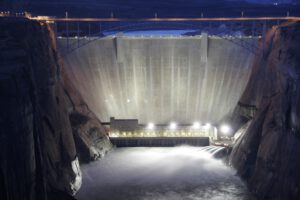
One of the prongs of the upper basin plan deals with operating our federal reservoirs, known as the Colorado River Storage Project initial units: Glen Canyon Dam, which creates Lake Powell; Flaming Gorge on the Wyoming-Utah line; Navajo in New Mexico; and the Aspinall Unit, which includes Blue Mesa, Crystal, and Morrow Point Dams in Colorado. We know that Reclamation would move uncommitted water from the upstream facilities down to protect Lake Powell because of its overriding importance in terms of power generation and compact compliance. The DCP gives us a seat at the table when there is a 24-month forecast that elevation 3,525 could be reached at Lake Powell and those drought operations are being contemplated.
The DCP states that if this dire situation occurs, we will continue operating under drought operations until hydrology improves and the storage in the three other initial units recovers. That’s important to the people who use Flaming Gorge in southwestern Wyoming and the other units in the other states. We have committed to carrying out those operations in accordance with existing environmental records of decision on the river. We are keenly aware of the need to operate within existing environmental requirements or records of decision so that we don’t have any kind of National Environmental Policy Act issues. The states committed early on to develop a drought operations plan that respected the environmental instruments that already exist on the river.
Wyoming also has Fontenelle Reservoir, which is upriver of Flaming Gorge. Recently passed federal legislation allows the State of Wyoming to work with Reclamation to add riprap to the lower part of the upstream face of Fontenelle Dam so as to make more of the reservoir usable for Wyoming. This work would add 80,000 acre-feet to the usable capacity of that reservoir. We already have 120,000 acre-feet of contracts in Fontenelle and anticipate entering into agreements to access the additional 80,000 acre-feet when it is needed. Our hope is that, if we ever get into compact compliance issues at Lees Ferry, Wyoming’s initial contribution could come from releasing or exchanging some of the water out of Fontenelle in lieu of regulating our users.
Joshua Dill: Why was federal government action and legislation needed?
Pat Tyrrell: To give you one example, there are components of the lower basin plan that might allow California, if it were to recover some of its conserved water, to physically divert a little over 4.4 million-acre feet in one calendar year. To allow that to happen without violating other parts of the Law of the Colorado River, new legislation was required. In the upper basin we needed legislation to bless our demand- management storage. The plan won’t work unless we have a place to store our conserved water. The federal legislation authorizes storage for the upper basin states to use, likely in Lake Powell, at no charge. It is an authorization that doesn’t expire. If we can successfully stand up a demand- management program and track the saved water down to Lake Powell, we will have the ability to use 500,000 acre-feet of empty space there to store that saved water and release it only if needed to maintain compliance with the 1922 compact.
Joshua Dill: Is the DCP significantly different from other multistate agreements and compacts you’ve negotiated in the past, and if so, how?
Pat Tyrrell: It has been more complicated and has required a lot more work. Our other compacts are with one or two other states. The Upper Basin Compact involves four states, and the original 1922 Colorado River Compact involves seven. We also have another country involved, the Republic of Mexico.
It is unusual that in 2011 and again this year we have seen large floods in the Missouri basin. We have also seen a lot of water in recent years in the Snake River and in Wyoming’s Bighorn and North Platte Rivers. We’ve also had a lot of snow in Wyoming in our Upper Green River basin, especially in 2017. Nevertheless, the Colorado River basin as a whole has not seen the plentiful runoff that would be needed to keep Lakes Mead and Powell full, or at least to keep them from dropping as they have. The drought is more severe on the Colorado River than in any other basin that I deal with in Wyoming.
Joshua Dill: What would have occurred if the DCP had not been passed?
Pat Tyrrell: It is difficult to say exactly what would have happened, but the failure to pass the DCP would have taken the lower basin states’ future out of their hands. The secretary of the interior is the water master below Lake Powell. I believe that lower basin states would have been faced with the need to short junior water right holders, primarily in Arizona, and to deliver water under the secretary’s less flexible authorities rather than through a voluntary program developed by the states. In either case, less water would have been available to the lower basin.
Joshua Dill: What is distinct about the situation of the upper basin and the situation of Wyoming in particular?
Pat Tyrrell: Wyoming is in the same boat as the other three upper basin states—Colorado, New Mexico, and Utah— although I think we are the furthest away from using our full apportionment. Wyoming doesn’t have huge irrigation or conservancy districts in our basin, certainly relative to Colorado, which has a large river district out of Glenwood Springs that has significant influence in the state’s decisions on the Colorado River. In Wyoming, none of our districts is as engaged, although we work hard to keep all our water users informed of activities on the river, including the DCP. Wyoming is also the only state in the upper basin that does not have a tribal presence on the river. In Wyoming, our only Indian reservation is on the Wind (Bighorn) River side of the Wind River mountain range.