
Joshua Dill: Please tell us about your background and how you came to be in your current position.
Michael Clancy: I am an officer in the U.S. Army. I am a graduate of the United States Military Academy at West Point and was commissioned in the Corps of Engineers.
I have spent most of my career in doing regular army stuff—serving in infantry brigades and other things people see in movies—but I’m also a civil engineer. I have a civil engineering master’s degree and a professional engineer license as a civil engineer. This is my third assignment in the Corps. I have had two assignments in the New York District and also spent 6 months in the Gulf Region Central District in Baghdad. The Corps of Engineers is a branch of the Army, but it is 99 percent civilian. There are just under 1,100 employees in the New Orleans District, only 6 of whom are in uniform. Most Corps districts are commanded by a colonel in the army. I was promoted to the rank of colonel and selected to be the commander assigned to the New Orleans District.
Joshua Dill: What are the responsibilities of the New Orleans District commander?
Michael Clancy: As New Orleans District commander, I was responsible for the civil works program in southern Louisiana. Through the civil works program, the army is the nation’s primary water resource agency. The program’s main components nationwide are navigation, flood risk management, and ecosystem restoration. Other missions include hydropower, water supply, recreation, and the regulatory program.
The Corps’s district boundaries follow watershed lines, unlike those of other federal agencies. The New Orleans District area of responsibility is approximately 30,000 square miles and includes everything between the Sabine River, which is the border of Louisiana and Texas, the Pearl River, which is the border of Louisiana and Mississippi, and the Red River, which slices across northern Louisiana.
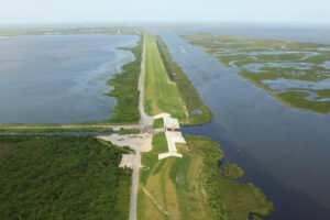
Every district is a little bit different based on its geography, but in the New Orleans District, my three main responsibilities were navigation, flood risk reduction, and ecosystem restoration. I was responsible for maintaining about 2,000 miles of federally authorized navigation channels. When it comes to flood risk reduction and flood control, the district deals with hurricane exposure as well as the yearly spring floods on the Mississippi River. Between river levees and hurricane levees, I was responsible for the maintenance of about 1,400 miles of levees. As for ecosystem restoration, the district is partnering with the State of Louisiana to rebuild the wetlands that have been lost across coastal Louisiana. As much as possible, it tries to beneficially use the dredge material produced during channel maintenance. That material can be put on land or used to rebuild wetlands. There is also the Coastal Wetlands Planning, Protection, and Restoration Act (CWPPRA) task force, of which I was the chairman. It consists of five federal agencies and the State of Louisiana. CWPPRA constructs a handful of projects every year, totaling about $80 million annually in coastal wetland restoration projects.
I’m sure your readers are familiar with getting a Corps permit. Technically, if you are going to build anything in the waters of the United States, you need a permit from the U.S. Army. I administered that for coastal Louisiana, which has a tremendous amount of wetlands. Our regulatory actions include granting various types of permits and jurisdictional determinations. We do about 8,000 regulatory actions a year.
My work also included the operations and maintenance of existing structures and the construction of new ones. That process kicks off with a feasibility study process in which we analyze the problem and submit recommendations to Congress for authorization and funding. There are about a half dozen feasibility studies in the works right now, mostly flood risk management related. Several authorized projects are now in the budget process. Last year, Congress passed the Bipartisan Budget Act of 2018, which responded to a terrible natural disaster season with multiple hurricanes, wildfires, mudslides, and river floods. It appropriated the New Orleans District about $2 billion in new construction money that will be used to evaluate and construct new flood risk management projects and to repair and reset existing federal projects that were affected by the recent river and tropical events.
Joshua Dill: Does the Corps work with any other agencies?
Michael Clancy: Everything we do is a team effort. Almost every Corps effort requires a nonfederal sponsor like the state or one of the levee districts that are responsible for levees throughout Louisiana. Most civil works projects are cost shared; the typical breakdown is 65 percent federal and 35 percent local. Nonfederal entities sponsor the projects and pay roughly a third of the costs. When we complete them, we turn them over to the nonfederal sponsors to own and operate.
Joshua Dill: Please tell us about how the New Orleans District worked to recover from Hurricane Katrina and protect against future hurricanes.
Michael Clancy: After Hurricane Katrina, Congress made a national commitment to the recovery and resilience of southeastern Louisiana.. The New Orleans District got $14.6 billion to upgrade the flood and hurricane defenses of the Greater New Orleans area. In effect, we built a 130-mile wall—either levees or concrete flood walls, depending on the location—that surrounds five parishes in the Greater New Orleans area. That is called the Hurricane Storm Damage and Risk Reduction System (HSDRRS). Our immediate goal was to make repairs as quickly as possible to the system that existed before Hurricane Katrina. Those were done about a year after the storm.
Our next goal was to build new stuff. We set ourselves a goal, which we accomplished, of building levees and walls to defend against the 1 percent, or 100-year, storm. This system was able to defend against a 100-year event by the 2011 hurricane season.
The environmental process followed by the HSDRRS program was unusual. We followed alternative National Environmental Policy Act regulations. Typically, an organization has to do an environmental impact statement, get all its permits before the project starts, and do mitigation concurrent with the project. In this case, the need and the urgency were so great that we built all the projects first and did the environmental compliance on the back end. That’s what is left to do today. Most of that is mitigation work—it’ll be the last thing we finish.
In the race to get the 1-percent system in place by 2011, we carried out some interim measures. We built some pump stations, for instance, that were out of doors and had no roof. We went back after 2011 and built more permanent structures. Something similar was true of the levees. Earthen levees are essentially just piles of clay, and they are constantly consolidating, or sinking. They need levee lifts on a routine basis, roughly once a decade. Over the last 2–3 years, we have been going back in partnership with the local levee districts to do levee lifts on the levees we built in the race to 2011 and to armor them. The armoring is a geotextile mesh net that goes over the top of the levee. We plant grass over that to bind it to the levee. That is so that if the levee is overtopped by storm surge, the water will simply flow over the top of the levee without eroding it or scouring it out. Although we were authorized and funded by Congress to build the defenses for the 1 percent storm, the system is designed to deal with a storm bigger than that. We learned many lessons from Hurricane Katrina, one being to build levees that are that are capable of being overtopped. The transition zones where earthen levees meet concrete sea walls could be weak points, but ours have been deliberately designed so that there is no weakness: The wall ties into the earthen levees wherever there is a transition, similar to the armoring on the earthen levees. The concrete walls have splash pads on the back so that if they are ever overtopped, the water will land on the concrete pad and not cause any erosion.
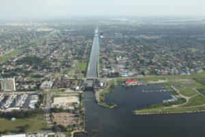
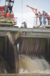
New Orleans is distinctive in its topography. It is crisscrossed by a series of outfall canals, which drain rainfall and water of every kind from the city. We cap them where they meet Lake Pontchartrain with massive gates and pump stations. We can close the gates so that the surge can’t back up in the canal, and the pumps pump the water out of the canals into Lake Pontchartrain.
About 50 percent of New Orleans is below sea level. It’s a giant bowl. Most places in the world are drained by gravity— not New Orleans. Every bit of water has to be moved mechanically. The local sewer and water board is responsible for that system. After Katrina, we helped improve the interior drainage of Orleans and Jefferson Parishes through the Southeast Louisiana Urban Flood Control Project, known as SELA.
Joshua Dill: What was the most challenging part of hurricane recovery?
Michael Clancy: I was not here at the time, but from what my colleagues tell me, the most challenging part was just scaling up the program. Everyone wanted to recover from Katrina and get the city back on its feet so that the citizens would have the confidence that we could make it through another major hurricane. It was a tremendous amount of work. There were dozens, if not hundreds, of contracts going at the same time and multiple contractors working on each site. In 2010, our peak year of construction, it is estimated that nearly 60,000 people were a part of the overall construction effort.
All the employees of the New Orleans District are from the area, so many of my employees were personally affected: Their homes were flooded and they lost everything. Not only were they trying to recover in their personal lives, they were working 7-day weeks to get all the work done that we needed to do to recover from the storm.
Joshua Dill: How did the Corps incorporate new techniques and technologies into the flood control infrastructure after Katrina?
Michael Clancy: After Katrina, the Interagency Performance Evaluation Taskforce studied what had happened in Katrina, particularly the mechanisms of failure wherever flood walls had failed. Those lessons informed all the work that has been done since. First, everything is bigger than what was there before Katrina. That concept is simple, of course, but building massive levees and walls takes a lot of geotechnical finesse. New Orleans is a tough place in which to build because most of the area is reclaimed wetlands. Some of our walls have massive piles that go hundreds of feet deep. We also incorporated all the stuff I mentioned: capping the outfall canals, levee armoring, splash pads. It’s a much more sophisticated and well-designed system than what existed for Hurricane Katrina.
Joshua Dill: Does your ecosystem restoration relate to your flood control work?
Michael Clancy: It does—it’s all interrelated. The topography here in southern Louisiana is interesting. The Mississippi River built all this land. It is the youngest land in North America: The ground under New Orleans is only 5,000–8,000 years old. Along the last few hundred miles of the Mississippi before it reaches the Gulf, there is a series of transitions from freshwater marsh to intermediate marsh, saltmarsh, and the open Gulf. Marshes are a transition zone, and in effect serve as Mother Nature’s storm defenses. We have the largest wetlands in the United States here in Louisiana, and in addition to being important from a natural and wildlife perspective, they are a component of our flood defenses. A general rule of thumb is that every mile of wetlands reduces storm surge by about a foot. A 20-foot hurricane surge would be eliminated entirely by 20 miles of marsh.
However, Louisiana has lost a tremendous amount of marsh over the last hundred years for a variety of reasons. One is that the Mississippi River is now confined by levees, so it does not overtop every year, flooding the land and depositing new sediment. Another big reason is that the coast was chopped to pieces in the 1930s, ’40s, and ’50s for oil exploration, drilling, and pipelines. As the marsh was cut bycanals,saltwaterintrudedanddestroyedthemarsh.The transition zone that I mentioned is a delicate ecosystem. Freshwater marshes, brackish marshes, and cypress swamps are all sensitive to salt. It will take a lot of work to recover from these changes. The State of Louisiana is taking the lead on that with its Coastal Protection and Restoration Authority, though the Corps assists it wherever and however it can; at the least we have to do the permits on their work.
Joshua Dill: What is the district’s vision for the future?
Michael Clancy: Our vision for the future is to keep pushing forward. HSDRRS got a huge flood of money after Katrina. We’re doing refinements like levee lifts and armoring, but we’re also doing two feasibility studies, one on each bank of the river, to decide what the future of the system should be as
and what the long-term federal responsibility should be. We’re building about 18 miles of newly funded levee north of New Orleans on the west shore of Lake Pontchartrain. We are also doing a lot of work in the Baton Rouge area. Baton Rouge had horrific flooding in August 2016. We’ve got $1.5 billion to address that. We are going to build a diversion canal for the Comite River, which goes through Baton Rouge, to divert part of it into the Mississippi River when it floods and to clean out other drainage ditches in East Baton Rouge Parish.
New Orleans just celebrated its 300th anniversary. The first French colonials started building their settlements there in 1718, and when everything flooded when the river came up in spring 1719, they started building levees. For 300 years, the people of southern Louisiana have been working on the levees. Back then it was the local government; the federal government got involved after the 1927 flood. It is a never- ending process that evolves as environmental conditions and the local topography change under the influence of the river or hurricanes. It is a cycle of reworking, redoing, improving, and incorporating new information and new technologies.
Joshua Dill: What are current conditions on the Mississippi like?
Michael Clancy: We are currently experiencing the longest flood in the history of the Mississippi River. We have surpassed the 1973 flood, the former record holder, which was at flood stage for 225 days. While folks who don’t live here usually associate New Orleans with hurricanes, the biggest flood risk we face on a regular basis is the Mississippi River. The Corps has been working on the Mississippi River levees for about 90 years, since the Flood Control Act of 1928. Just like the work on the hurricane system, it is a never-ending process of levee lifts and improvements. It is truly remarkable that we are in the middle of the biggest flood in the history of Mississippi River, and nothing that’s not designed to be flooded is flooded right now. There’s no loss of life or major loss of property. All the levees are in good shape even after months and months of pressure from the river. That is a testamenttothegreatworkwe’vedoneovertheyears.