
 Tyler Young: Please tell us about your background and how you became involved with the San Pedro Creek Improvements Project.
Jeffrey Mitchell: Interestingly for an article in a municipal water publication, my background is in structural engineering. I received my bachelor’s and master’s degrees from the University of Texas at Austin. After that, I went to work for a local engineering and architecture firm in San Antonio, which soon became part of the HDR Engineering, Inc., family, and I practiced structural engineering with a focus on civil works. I primarily worked on water and wastewater infrastructure projects for the first 15 years of my career. I was mostly technically focused on civil and infrastructure projects and worked in several of the HDR offices across the nation.
In the early 2000s, when I moved back to San Antonio from the eastern United States, I began work on an important series of local projects for the San Antonio River Authority. These were an expansion and extension of what is commonly called the downtown River Walk. To us, it was called the Museum Reach of the San Antonio River and encompassed both the Urban and Park Segments. The Urban Segment involved extending linear park amenities along the San Antonio River about 1⅓ miles from where they had stopped in the downtown area back in the 1930s. This area of the San Antonio River had essentially become a forgotten drainage ditch and was not fully developed. When construction on the project finished in May 2009, we had improved flood control, expanded linear park amenities, improved public access, and allowed riverboats to travel from the downtown area to the Pearl redevelopment. This sparked a lot of excitement in the San Antonio community. At the beginning of the project, I was the structural engineer, but due to internal staffing changes I found myself in charge of most of the engineering design and management for the project. This marked a transition for me from the purely technical focus of structural engineering to the broader scope of design team and project management. But my roots were still structural. The Park Segment projects continued to extend accessible trails and amenities from the end of the Urban Segment up into Breckenridge Park. Construction wrapped up around 2014.
 As these projects were winding through to completion, our client, the San Antonio River Authority, working as project manager for Bexar County, continued its mission of river improvements by launching the San Pedro Creek Improvements Project. The goals of this project were similar to those of the Museum Reach projects—flood control, linear park-like amenities, local art, water quality improvement, pedestrian connectivity, and economic development—but were applied to a different historic waterway in downtown San Antonio, and with a very different artistic vision. The San Pedro Creek Project started to be a local conversation around 2010 and 2011. A professional engineering study and report were launched. HDR was not a part of that, but when the final design for the San Pedro Creek Project came out for proposal in late 2013, we became involved. The San Antonio River Authority was pleased with the work we had done on the Museum Reach projects, so they requested HDR’s involvement in the San Pedro Creek Improvements Project, and I was fortunate to be a part of that.
Tyler Young: What sparked the need for the San Pedro Creek Improvements Project?
Jeffrey Mitchell: To understand that, you have to understand the history of San Antonio and the community’s psyche. As long as people have been gathered and organized here in San Antonio, there has been interest and passion for the local waterways. When the first Spanish explorers came, they were taken by the quality and opportunities provided by the San Pedro Creek and the San Antonio River.
The San Pedro Creek was the first waterway that was recorded in the accounts of the early Spanish explorers. Of course, there were local indigenous people arranged around the waterways before the Spanish arrived because water was a life-giving necessity in an otherwise hot, dry, central Texas landscape. The early Spanish settlers dug ditches or acequias off the waterways that conveyed the spring-fed water out for public use for things like crop irrigation. Punctuated throughout the history of the city were also major flood events. The area is flat, so during large rain events, the San Antonio River, the San Pedro Creek, and other tributaries would flood violently, inundating major portions of the inhabited area and causing destruction. As a result, gradual deepening and widening measures have been undertaken to insulate the habitations of the city from the floods. As the city grew, people shifted to groundwater as a more reliable and safer source of public water. This increasing shift to groundwater eventually caused the springs to flow less or even to dry up for periods of time.
Today, water remains a big topic in the central Texas area. While San Antonio still relies mostly on groundwater, we do harvest, transfer, inject, and store groundwater between aquifers as a way to even out the demand between groundwater sources. We have also begun to increasingly treat and use brackish groundwater that was previously not used for municipal water supply. In San Antonio, there is a day-by-day inventory of the level of the Edwards aquifer to help govern the local water supply and manage drought restrictions. Due to the Wastewater Treatment and Reuse Program, the San Antonio River also benefits from a reliable source of water to ensure perennial flow through the city. As a result, there is a dedicated minimum amount that always keeps flowing along the San Antonio watershed. This flow helps keep the River Walk alive.
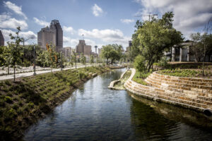
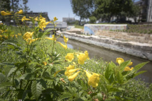
Similarly, the San Pedro Creek only flows when San Pedro Springs are high, which these days is not very often—this year being an exception. The San Pedro Creek does join up with the San Antonio River downstream of the downtown area of the city. Since the San Pedro Springs are now intermittent and unreliable, without perennial flow, people had more or less turned away from the San Pedro Creek in terms of development and focus. The creek became more of a divide and a separation within the community, rather than an attraction to pull people in and together. Really, the genesis of the San Pedro Creek Improvements Project was to revitalize that whole corridor, filling it with water to make it a park where the people of San Antonio would come to walk and gather and be inspired and refreshed.
Tyler Young: Would you tell us about some of the challenges the project has faced?
Jeffrey Mitchell: One of the big challenges we have faced has been in the area of funding. Locally, in 2013, Bexar County was generous enough to fund $125 million of the initially estimated project cost of $150 million to lead us into the final design. Unfortunately, by the
40 percent design milestone, the cost of accomplishing all the important project goals along the full, 2.2-mile-long project corridor was identified to be significantly more. That reality has set up a schedule and scope interaction that persists to this day and will continue until everything is finished.
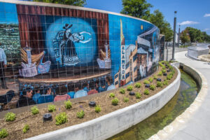
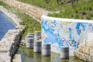
One of the first responses to the budget reality was to divide the single project into a series of four linear phases, to be completed sequentially, as funding remains or becomes identified. The initially committed funding has been applied to the more urban area upstream, designated as phase 1, and design and construction has been working its way downstream. Phase 1 has now been further divided into three subphases, 1.1 through 1.3. Phase 1.1 is about a half-mile long and starts at the upstream beginning of the project—the inlet to the underground flood bypass tunnel—and extends a little more than three city blocks south. Phase 1.1 was fully constructed and functional by San Antonio’s tricentennial celebration on May 5 of this year. This half-mile stretch includes almost 4,000 linear feet of accessible walkway; four impressive tile murals featuring the work of local artists; 38 benches adorned with custom tile designs; one crest gate and control building, which is concealed as a locally inspired gatehouse art feature; five bioswales; and an award-winning array of trees and other native landscaping. It is impressive and has been well received.
 Another challenge the project has needed to overcome is a tight project corridor—the creek has been there since the founding of the city, and the city has grown up close to its banks. Therefore, the project corridor is tight and runs through the most historic areas of downtown. All construction has to respect antiquities-code requirements regarding archeological monitoring and impacts to historic infrastructure. This tight project corridor is also packed with existing utilities that have had to be carefully worked around or relocated as the creek has been both widened and deepened to accomplish both the flood control and pedestrian access. When complete, the flood-control goal for the project is to take 25–30 acres out of the current 100-year floodplain. This flood control goal will make development possible on land that is currently within the floodplain.
Another critical aspect of the project is maintaining a constant flow of water at carefully controlled water surface elevations, which also accommodate the peak flows of storm and flood events without exceeding the creek banks. The water surface control is accomplished with hydraulically actuated, bottom-hinged steel crest gates, similar to the gates installed in the Museum Reach and elsewhere in the city. These gates fold down during storm and flood events to get out of the way and then automatically rise to recapture the desired water surface profile as the storm flows recede. The constant creek flow is accomplished by taking advantage of pumping infrastructure already in place as part of the underground flood control tunnel constructed under the authorization of the U.S. Army Corps of Engineers in the 1980s. We’ve had to augment the water supply accessible to San Pedro Creek by creating a pumped, underground cross-connection to the San Antonio River and ensuring that a sufficient supply of reuse water is available for both tributaries in the watershed. Supplying water to the creek in this way helps insulate its flow from the drought restrictions that are an annual reality in San Antonio.
I mentioned the constrained right of way earlier. The construction process, including getting construction
equipment down in the channel of an active creek that flows significantly every time it rains in the watershed, is a challenge, to say the least. We have tight constraints for getting in and deepening down the riverbed. The city has been built over centuries, so the level of existing conditions that need to be navigated around, discovered, and rediscovered is staggering. Storm drainage systems and other elements of infrastructure are not always where you expect them to be. When you discover where they really are, the design has to respond to that.
Another significant challenge has been time. The initial vision for this project was to have all 2.2 miles completed for the city’s tricentennial on May 5, 2018. Everyone realized after the first few months of the project that this goal was not feasible. After that, the challenge was to maintain focus on a significant core portion of the project that could be completed by the tricentennial. That portion eventually became phase 1.1, which was opened and commemorated on time on May 5. This was a huge project success.
Tyler Young: What advice do you have for your peers?
Jeffrey Mitchell: I think in the context of my career, I have learned to try to keep the bigger picture of the broader benefits for the community at the forefront.
 It is important to be able to look past the grind of the daily project challenges and focus on what the project will do. Often this is hard to do. So sometimes over the course of the San Pedro Creek design, when I was travelling and away from home, I would take myself back to the Museum Reach and have dinner at one of the eateries that grew up along it, to remind myself of the benefits that were to come.
Expecting the unexpected is also key. As engineers, we want to have things carefully choreographed, but on projects like these highly urban river improvements adventures, things seldom happen according to the original script. Being nimble and responsive and delivering quality service in an ever-changing environment is important. Keep the focus on what can be done from where you are. In terms of management, I think it also helps to be curious, interested, and engaged in the minor details. I have certainly learned so much outside my original area of structural engineering through the projects that I have served on. Keeping that curiosity, learning, understanding, and broader interest has been important for me.