
 Joshua Dill: Please tell us about your background and how you came to be in your current position.
Phil Rosentrater: I arrived in Southern California fresh out of college with a background in chemistry and political science. I soon came to realize the importance of water in this arid environment. Through my work in campaigns and communications, I developed a deep affinity for water issues in the Southwest.
For the decade prior to being recruited to work at the Salton Sea, I served as the external affairs director for Western Municipal Water District in Southern California. Western is both a wholesale and retail water supplier to a population of 880,000 people in a 527-square-mile portion of rapidly growing western Riverside County. Because the agency has little water of its own, most of its supplies are imported both from the State Water Project and the Colorado River. I had the privilege to be involved in a successful effort to diversify the water portfolio by developing new sources from stormwater capture, groundwater recharge, desalination, and recycled water use. Developing a resilient, integrated portfolio requires an awareness of the complexity of water supply and strong, diplomatic relations with a broad range of partners. I led the charge in successfully protecting the district’s financial resources from external threats while also working with a team to capitalize our projects with significant state and federal investments. As I built a reputation for tireless coalition building and affecting policy at the local, regional, state and federal levels, leaders from the Riverside County approached me with a challenging proposition.
The Riverside County supervisors, who serve with other elected regional leaders on the board of the SSA, were increasingly alarmed by a looming disaster on the Salton Sea. They decided that the SSA needed someone with my skillset who was willing to drive change by developing overlooked local resources to accomplish a sustainable, prosperous solution for the long term. I parachuted into the economic-development side of the house to channel those resources and build those partnerships.
Joshua Dill: Please tell us about the SSA.
Phil Rosentrater: The SSA was founded in 1993 by the consent of the partnering agencies who realized that the challenge of Salton Sea revitalization is larger than any single entity can address on its own. It is a joint powers authority empowered by State Law AB-71 to work in consultation and cooperation with the California Natural Resources Agency (CNRA) on plans to revitalize the Salton Sea. The SSA comprises the two major land-use agencies where the Salton Sea is located, Riverside and Imperial Counties; the two major Colorado River–water importing agencies, Imperial Irrigation District and Coachella Valley Water District; and one of the major local landholders, the Torres-Martinez Tribe of Cahuilla Indians.
Joshua Dill: You referred to the situation on the Salton Sea as a looming disaster. Would you tell us about the situation there and what caused it?
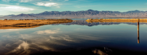
Phil Rosentrater: First, let me describe the Salton Sea. It is California’s largest lake, and is a terminal lake with no outlet. It is located at the second-lowest elevation in the United States, after the basin of Death Valley. The Salton Sea has ebbed and flowed over the eons, with its water coming primarily from Colorado River storm flows. The delta created between the sea and the Gulf of California, also known as the Sea of Cortés, is composed of sediment that washed out of the Grand Canyon, among other sources. From 1824 to 1904, the Colorado River flooded the valley at least eight times. The sea in its current form, with a surface area of 343 square miles, was created in 1905 when El Niño storm flows on the Colorado River roared through a breach in one of the irrigation canals and continued flowing for a year and a half. In the decades that followed, agriculture developed around the sea, enhanced by executive orders by President Coolidge in 1924 and 1928 designating the Salton sink a federally recognized agricultural drainage area. To this day, the sea is sustained by ag flows from the surrounding cropland, which is irrigated by Colorado River water. Both the water from the Colorado and the agricultural drainage, which essentially rinses the area’s farm soil to maintain its agricultural viability, contains a fair amount of salt. That salt ends up in the Salton Sea and concentrates there as the water evaporates in the high heat. Due to reduced flows, the salinity of the Salton Sea is rapidly approaching twice that of ocean water.
The Salton Sea eventually became a major nesting ground for a massive and diverse population of birds migrating along the Pacific Flyway. At its high point, more than two-thirds of the known species of migratory waterfowl in North America were known to spend some of their lives in the Salton Sea, where they fed on fish and insects. A lot of them are fish-eating birds that feed on tilapia, which grow in the millions in the sea. As the salinity of the Salton Sea rises, food sources like tilapia are stressed and left unable to reproduce. This leaves migratory birds that spend part of the winter at the sea hard pressed to survive.
Not only is the salinity rising, the total volume of water in the sea is actually shrinking. This is a consequence of the largest ag-to-urban water transfer in U.S. history. The amount of Colorado River water allotted to agencies in California was reduced to 4.4 million acre-feet in 2003 as part of an agreement called the Quantification Settlement Agreement (QSA). California had been taking more water than it was actually entitled to: In years in which other lower Colorado River basin states didn’t use all of their water, California took it, rather than let it drift unused into the Gulf of California. When states like Nevada and Arizona grew to the point that they needed their full allotment of water, California was ordered to cut back to within its allotted 4.4 million acre-feet a year. In order to manage these limited water resources, agricultural irrigators transferred large amounts of water to urban users—meaning that some of the water that once flowed into the irrigation areas around the Salton Sea now bypass it and go to the coast—while the State of California agreed to mitigate and restore the portions of the sea that would be affected by the transfer.
The challenge caused by the shrinkage and increased salinity of the Salton Sea is threefold. The exposure of significant portions of emissive lakebed, or playa, could lead to dusty soil becoming airborne, posing an enormous potential threat to human health. There is also a threat to animal habitat on an international scale, given the intercontinental reach of the Pacific Flyway. Those two threats also pose a serious economic threat to the region. The immediate threat is to the $2 billion-a-year agricultural industry, which supplies two-thirds of the winter produce consumed in America, plus the $6 billion-a-year tourism industry in the Coachella Valley, which is home to some of the finest golf and tennis resorts, equestrian facilities, and outdoor concert events to be found in America. If no action is taken, those economic resources are at risk of being hit by dust storms from 100 square miles of emissive playa. A situation in which dust storms cover the area’s crops and threaten the food security of the United States would be a disaster extending far beyond the Salton Sea. Likewise, if winds rage through the region—which does happen from time to time—the dust from an untreated lakebed could threaten the health of tens of millions of people living in the Los Angeles air basin.
The good news is that plenty of water still comes into this area, allowing us to cover those dusty areas if we are careful stewards of funding and hydrology. SSA agencies and partners at the state level have learned from both the successes and failures of similar entities and projects around the world. We have a pretty good idea of what will work, and
we have a set of resources around the Salton Sea that we can harness and integrate into a solution that will sustain and transform the region into a healthier, more prosperous future.
Joshua Dill: Will the overall solution involve increasing regular flows of water into the sea?
Phil Rosentrater: Increasing water flows to the sea is a tough proposition in watersheds challenged by drought, and the Colorado River basin, of which the Salton Sea is the lowest point, is currently suffering one of the longest and most severe droughts of modern history. That means that water use efficiency is paramount.
That said, if this region is going to continue to produce two-thirds of all the winter crops in the United States, irrigation water will still need to flow to the fields, and that will drain into the sea. The human population of the area will also require water. The challenge then becomes deciding how best to use and manage the flow of drain water into the sea. The future agricultural production in the basin is estimated to drain around 750,000 acre-feet of water a year. Currently, the state’s Salton Sea Management Plan (SSMP) calls for capital investment to install levees that will impound those flows before they drain all the way to the lowest point of the hypersaline brine sink. These measures will create a stable shoreline, covering the otherwise exposed playa, and restore some habitat. There will be less water, but we don’t necessarily need to fill the entire water column across the entire lake. The SSMP design foresees terrace ponds extending down from the outer edges of the sea, where the elevation is higher, to the middle, where it is lower. In that way, the limited inflows will be used to wet the dusty soil; restore habitat; and, where feasible, create some recreational areas.
Joshua Dill: What are the SSA’s top priorities right now?
Phil Rosentrater: As always, the SSA’s top issue is maintaining cooperation among its member agencies, between the SSA and the State of California, and among those entities and the State of California and our federal partners. Multiple jurisdictions overlay the Salton Sea; our challenge is to address the concerns of all those partners in a fair and equitable manner and with consistency and consensus. That is a goal that has not been easily achieved over the last 3 decades. That was, in my view, the primary impediment to progress. As we gained a more solid coalition of people who were willing to talk and compromise and seek common solutions, we have found a path forward.
Once we developed feasible plans, we needed to find a way to fund them. That is the point we are at now. We have a 10-year plan and projects in the pipeline that have been agreed to by the locals who comprise the SSA, the NGOs and the environmental groups, and the CNRA.
Our challenge is to fulfill the mandate of State Law AB-71, which calls on the CNRA to work in cooperation and consultation with the SSA on matters pertaining to the restoration of the Salton Sea. That requires a lot of coordination. In November 2017, the State Water Resource Control Board formally adopted the SSMP, which had been hammered out by the state and the partner agencies of the SSA, and a performance schedule defined in a stipulated order. A total of $280.5 million has been directed to the 10-year projects of the SSMP. Now it is time to start implementing.
Joshua Dill: What are some of the planned projects?
Phil Rosentrater: The immediate solutions are projects that intercept flows at the main tributary points around the Salton Sea. There are three of these: the New and the Alamo Rivers on the south end of the sea, which are mostly composed of ag drainage, and the Whitewater Storm Channel on the north end, which delivers ag drainage and some treated domestic wastewater. The SSMP calls for levees that would impound some of this water to create habitat to sustain the Pacific Flyway and to cover stretches of dusty lakebed. Those projects are designed in a manner that allows for their replication and expansion around the shoreline. We also have the opportunity to rehydrate some of the once-thriving marina communities around the lake. This will also produce deep water habitat that can sustain portions of the Pacific Flyway. The levees would follow the shoreline, in some cases more than a mile offshore. The concept is to establish the first phases of a smaller but healthier lake at the points where the main tributaries enter the sea. Once those backbone components are built, additional segments and phases can be built out in incremental fashion around the edge of what is being called the Perimeter Lake.
Joshua Dill: Please tell us about how the Salton Sea affects California as a whole.
Phil Rosentrater: It goes beyond California—it affects the entire American Southwest and parts of Mexico. Any arrangement that transfers water out of the Salton Sea basin potentially exacerbates the shrinkage of the lake, worsening health threats across Southern California and into Mexico, endangering the international Pacific Flyway, weakening America’s winter food supply, and causing economic damage that extends far beyond the sea. This must be taken very seriously. Those who seek such transfers need to acknowledge that there will be consequences. Sometimes those consequences can be mitigated. The state’s current SSMP places a premium on mitigation. We think that we have a sensible, achievable, actionable path forward that is not ridiculously costly or punitive. It’s taken years to get here, but we are on that trajectory.
Joshua Dill: Please tell us about the resources that the SSA can develop as part of its plans.
Phil Rosentrater: From the perspective of developing resources, progress begins at the Salton Sea at the moment when one recognizes the sea as an asset and an opportunity, not a liability. Let me give you a couple of examples. The Salton Sea was at one time the number-one tourist attraction in the State of California, exceeding Yosemite in its number of annual visitors. The recreational economy of the Salton Sea can be restored, not perhaps to the full extent of its heyday, but substantially. We can actually restore fishing, boating, and recreational activities by rehydrating marina communities. That will increase property values and the property tax base. That revenue can then be captured and directed to debt service on the very infrastructure bond that will create the benefit. Over time, that development will increase the sales of boats, restaurants, hotels, and so on. That generates sales tax, bed tax, and other revenue sources that can be captured and directed to maintenance. This is a realistic scenario. Riverside County has successfully used this financing mechanism, known as redevelopment, for decades.
On the southern end of the sea is the largest commercially viable geothermal energy source in North America. Numerous power plants are already operating there, with potential for expansion to create a carbon-free, 24/7 reliable energy source that can power a modern economy. Someday, this giant power supply may be tapped, sustaining the southwestern United States not just with enhanced water security but with baseload supply.
In recent years, we’ve learned that the geothermal brines themselves are chock-full of valuable metals and minerals, specifically lithium. Rising worldwide demand for computers, cell phones, and electric cars generates demand for lithium batteries. A mineral that once presented an operations and maintenance problem for the geothermal industry at the Salton Sea may become a resource that contributes to the sea’s long-term sustainability. Likewise, the agricultural flows that sustain the sea also contain substances once thought to be problematic. Fertilizers in ag drains occasionally grow algae in the sea on a scale found nowhere else in the United States. When one considers that algae is a prime feedstock for biofuel, it may also reliably supplement carbon-neutral fuels. Algae may someday be deployed in ponds around the sea to bioremediate the fertilizers, producing cleaner water for habitat while generating feedstock for biofuel, and all the while helping improve air quality by covering the dusty playa.
Our strategy is to drive consensus on pragmatic projects around the sea that harness overlooked resources currently mischaracterized as waste, and to transform a promising asset dismissed as a hopeless cause and an endless liability into a dynamic engine for recovery. The SSA and its partner agencies have demonstrated the will to create consensus and to work cooperatively with state and federal partners. As we continue to integrate our scarce resources in pragmatic, achievable steps forward, we have the makings of a much healthier and more prosperous future for the Salton Sea.