
Municipal Water Leader: Please tell us about your background and how you came to be in your current position.
Andrea Doyle: I have been the director of the Office of Chehalis Basin for 3½ years. I sought out the position after spending most of my career in a variety of different environmental and legal positions in the public, private, and nonprofit sectors in Washington. Through those different experiences, I’ve led a range of legal, policy, regulatory, and advocacy efforts and have become convinced that collaborative approaches produce the most positive and durable solutions to complex environmental issues. This opportunity was a great way for me to bring my passion and experience to bear on one of the biggest challenges facing the Chehalis River basin, namely the complicated intersection of the economic effect flooding has on communities and the floodplain habitat needs of salmon and other important aquatic species.
Municipal Water Leader: Please tell us about the Office of Chehalis Basin.
Andrea Doyle: The Office of Chehalis Basin was created by our state legislature in 2016, after about a decade of work initiated by former Washington State Governor Christine Gregoire. After the basin experienced devastating floods in 2007 and 2009, she convened a work group of community leaders and stakeholders to develop a long-term plan to protect basin communities from future catastrophic flood damage while also restoring aquatic species. The legislature later elevated its work into a formal state office and placed it under the direction and oversight of an independent board, the Chehalis Basin Board. We now work out of the Washington State Department of Ecology.
Municipal Water Leader: Please tell us about the Chehalis basin’s geographic and environmental characteristics.
Andrea Doyle: The Chehalis basin is a truly unique and special place. It is located in southwestern Washington, about halfway between Seattle and Portland, and is the state’s second-largest river drainage system. The 2,700‑square-mile watershed boasts more than 3,400 miles of rivers and streams. The Chehalis River itself is more than 125 miles long and drains into the Pacific Ocean through a large estuarine bay called Grays Harbor, which is midway between two much-better-known geographical features: Puget Sound and the mouth of the Columbia River.
Geographically, our basin covers 10 distinct ecological zones and includes densely forested old-growth areas, rolling mountain foothills, fertile farmlands, valley floors, and marshlands along the Pacific Ocean. The Chehalis River and its tributaries are home to some of the most culturally and ecologically important species in our region, including steelhead and seven types of salmon, including Chinook, coho, and chum salmon, just to name a few. It’s also the only remaining river basin in the state of Washington where no salmon species are listed as threatened or endangered under the federal Endangered Species Act. One fun fact about our basin is that it also home to Washington State’s most diverse assemblage of amphibians, such as frogs, toads, and salamanders.
Municipal Water Leader: Would you tell us about the basin’s human population?
Andrea Doyle: The current population of the basin is about 220,000 residents. The bulk of that population is centered along I-5, a major interstate highway that runs north-south from Canada to Mexico. The other population center is in the harbor area around the mouth of the Chehalis River. What we call the Chehalis basin today is made up of the ancestral lands of many different tribes. Two of those sovereign nations continue to reside in and use the basin today: The Confederated Tribes of the Chehalis Reservation reside in the heart of the basin, and the Quinault Indian Nation has treaty-protected rights to fish, hunt, and gather in part of the basin. People in the Chehalis watershed remain closely connected to the land and river system, with working forests and farmlands making up a large percentage of the basin’s land uses, and commercial and recreational fishing contributing significantly to the region’s economy.
Municipal Water Leader: How was the Chehalis Basin Strategy launched?
Andrea Doyle: As I mentioned, it was initiated as a community working group by former Washington State Governor Christine Gregoire. The early work aimed to increase our scientific understanding of the hydrology of the basin as well as the fishery science relating to it. A major effort was undertaken to do what we call a programmatic environmental impact statement, which is a broad-scale, planning-level review of different approaches and options that could address both the fish and the flood objectives of the strategy. That resulted in a robust body of science that informed project selection and now informs the policy work that folks are engaged in.
Municipal Water Leader: Was that initial analysis carried out by the Office of Chehalis Basin?
Andrea Doyle: The programmatic review was performed under the direction of the Department of Ecology, the Department of Fish and Wildlife, and other state agencies. It was done with the assistance of many external consultants specializing in a variety of disciplines and resource areas. For example, consultants assisted with hydrology and hydrologic modeling and analysis, wetlands and vegetation analysis, fisheries modeling, geology and geotechnical engineering analysis, and land use and transportation analysis, to name a few.
Municipal Water Leader: What is the main problem that the Chehalis Basin Strategy is designed to address?
Andrea Doyle: The strategy was launched in 2010 to meet two of the basin’s biggest challenges by reversing the decline of salmon and other aquatic species and protecting communities from catastrophic flood damage. The floods of 2007 and 2009 were some of the most damaging floods we’ve experienced. Five of the basin’s largest floods on record occurred in the last 35 years. As climate change continues to increase the scale and the frequency of major floods around the world, the Chehalis basin is predicted to see more-frequent atmospheric river events, which will unleash 25–50 percent more precipitation than storms in the past. We’ve also seen that while aquatic species like salmon are not currently listed, several of them are on the brink. In the upper basin, salmon and steelhead populations are predicted to decline by another 70 percent from currently depleted levels if we don’t implement aggressive protection and restoration actions. It is the urgency that comes with knowing that both issues are going to get worse if we don’t take bold and aggressive action that has caused people to solidify around this collaborative process.
Municipal Water Leader: What are the main goals of the strategy?
Andrea Doyle: We have a unique opportunity to address our dual goals of fish and flood protection together through a thoughtful and integrated approach. We know there is not any single simple solution to meet either of these important objectives on its own, so our goal is to use multiple reinforcing actions at every scale to make the basin safer and more resilient for both humans and aquatic species.
Municipal Water Leader: How do the goals of flood reduction and fish habitat protection affect each other?
Andrea Doyle: The issues of flooding and fish habitat are intimately connected. The floodplains are where the increase in the frequency and the intensity of flooding will cause the greatest damage. The floodplains are also where the best habitat is—or at least where it should be—for fish and other aquatic species.
These issues intersect in the floodplains, and they create some challenges because of competing interests regarding how certain lands should be used, managed, and developed— or not developed. But we view carrying out fish and flood projects at the same time less as a challenge and more as an opportunity to provide mutual benefits on both a regional and site-specific basis. We work on a voluntary basis with willing landowners. In doing that, we aim to center their interests and needs as we plan which projects to implement and where to implement them. The good news is that many of the projects that we’re able to pursue have benefits for both aquatic species habitat and flood damage reduction.
We have a lot of projects that we like to think of as integrated fish and flood projects that provide direct benefits in both key areas. Some of the best examples are projects that focus on protecting critical public infrastructure, such as wastewater treatment facilities, or protecting farm equipment industrial areas, which can leak oil, gas, and other toxic pollutants into the water if there’s a flood, which obviously can harm the ecosystem. By protecting that critical infrastructure from flood damage, we also protect the ecosystem and habitat. On the flip side, when we do floodplain habitat improvement projects, such as projects to restore riparian function or to reconnect floodplain areas to their river channels, we can increase the capacity of the floodplain to absorb, store, and slow down water in the event of a flood.
Municipal Water Leader: What are some of the main projects that are part of the strategy today?
Andrea Doyle: The strategy includes a range of projects of different sizes and types. Collectively, since 2012, we’ve invested over $100 million in more than 100 completed or ongoing local projects to reduce flood effects and to help salmon and other at-risk aquatic species.
We have large-scale projects on both the habitat side and the flood-damage-reduction side of the strategy. On the flood side, for example, cities around Grays Harbor are teaming up to design and permit the major improvement of a levee to protect the cities along the north shore of the harbor. That large-scale project is designed to protect over 2,000 properties and over 360 businesses from floods. The largest-scale proposal that is currently being discussed is for a potential emergency flood-protection facility that would retain up to 65,000 acre-feet of floodwater near the headwaters of the Chehalis River during a major or catastrophic flood event. That project is still undergoing environmental review, and no decision has been made yet about whether it will be implemented as part of the strategy.
On a smaller scale, we have worked in partnership with our local flood authority, which is made up of local governments. They have identified projects to protect local government infrastructure, and we fund the study, the project design, and the implementation of the highest-priority projects. Those are things like drinking water protection; public road protection; detour routes; and flood warning systems, which local governments are continuing to improve to help notify their residents in the event of future floods. We’re also providing technical assistance and some financial assistance to individual residents, business owners, and local and tribal governments to fund flood-proofing and flood-protection projects on a parcel-by-parcel basis.
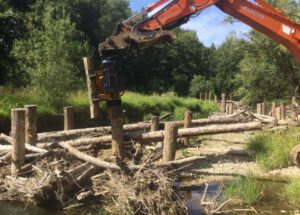
On the habitat side, we have an ambitious 30‑year aquatic species restoration plan that involves investments in the protection and restoration of more than 550 miles of prioritized river habitat. Those projects are being implemented in several ways, but the largest ones are on 1- to 3‑mile reaches of riparian and adjacent lands whose landowners are willing to allow conservation and restoration measures. We have also ramped up our investments in different types of smaller-scale habitat restoration activities, such as fish passage barrier corrections or removals, that can be deployed throughout the basin.
Municipal Water Leader: Are there any existing flood-control reservoirs on the river now?
Andrea Doyle: There are none on the mainstem of the Chehalis River itself. There are two reservoirs associated with dams in its tributaries, although neither is designed and operated for flood protection. There is a lot of interest right now in looking at one of those facilities, the Skookumchuck Dam, which provides incidental flood-protection benefits. The Chehalis Basin Board is currently looking at ways in which the operation of that dam could be modified to improve its flood-protection capabilities. They are also looking at ways in which potential modifications to the dam could benefit fish or upstream habitat through better fish passage facilities, what dam removal might mean for the fisheries in that tributary, and the implications of dam removal for downstream flooding.
Municipal Water Leader: How is the strategy being carried out in a way that respects tribes’ rights and perspectives?
Andrea Doyle: Tribal involvement and engagement have been absolutely critical. This strategy wouldn’t have been as successful as it has been to date without the tribes’ involvement, and we know that it won’t be successful in the long run without their support. The two sovereign tribal nations in the basin, the Confederated Tribes of the Chehalis Reservation and the Quinault Indian Nation, have been involved in the strategy since its inception. Both of those tribes have representatives that serve on the Chehalis Basin Board, a nine-member oversight board that operates on a consensus-based-decisionmaking model. The two tribes were coauthors of the aquatic species restoration plan and serve on its steering committee. The plan is a major component of our strategy and has received widespread support and praise from basin residents, scientists, and local leadership. Both tribes also serve on the steering group of a newly formed Local Actions Non-Dam (LAND) alternative evaluation team. They are intimately involved in all parts of the strategy, from serving on the oversight board to steering both habitat-protection and flood-damage-reduction work.
Municipal Water Leader: How is the strategy being funded?
Andrea Doyle: The vast majority of the funding for the Chehalis Basin Strategy comes from the Washington State Legislature. We’ve been incredibly fortunate, and we are exceptionally grateful to our state legislative champions, including Representative Steve Tharinger and Senator John Braun, who have been tireless in their exceptionally successful advocacy on behalf of the Chehalis Basin Strategy. We also partner with other organizations on many of our projects, and in many of those cases, project partners bring additional sources of funding to the table. At the federal level, we work closely with Congresswoman Jamie Herrera Beutler and Congressman Derek Kilmer, who have been very attentive to the needs of the strategy. We’re looking to expand our funding sources in the future, and we’ve been laying some good groundwork with our congressional delegation to do that.
Municipal Water Leader: What kind of results do you expect to see from the strategy in the next 5, 10, or even 50 years?
Andrea Doyle: Over the life of this strategy, to put it simply, we expect to see safer communities for people, stronger local economies, and healthier ecosystems. We are already seeing tangible results from projects we have implemented, such as the removal of 56 fish passage barriers, which has opened or improved access to more than 178 miles of stream habitat for migrating salmon and steelhead; the protection of dozens of homes, buildings, farms, and wells from floods; the protection of a wastewater treatment plant from riverbank erosion, which could have breached the plant and potentially released millions of gallons of raw sewage into the river; and the protection of a local airport using storm pumps.
We look at future time horizons in a few different ways. We’ve got the immediate projects that we’re working on—in summer 2021 alone, crews worked to restore over 12,000 feet of river shoreline and to treat almost 300 acres for invasive plants, benefiting salmon and the other aquatic species. We’ve also recently completed the protection of over 360 acres of floodplain habitat through various property acquisitions and conservation easements. We’re installing the final elements of a new flood-protection project in the city of Centralia to keep a local creek that is currently diverted underground through the heart of the city from flooding the downtown area during periodic 5- to 10‑year flood events.
If we can keep this collaboration moving ahead, we expect to achieve up to 550 miles of restoration and to better protect the residents of thousands of existing homes and other structures that are currently at risk of flooding or that we expect to be at greater risk of flooding in the future. We also expect that we can help local governments redirect new development away from high-flood-risk areas by using the best available climate change projections.
While we hope to be aggressively implementing projects over the next 30 years, we look at a 50‑year timeline when considering the effects of our actions—or inaction. If we’re not able to take aggressive action now, what will that mean by the latter part of the century? We want to avoid the extirpation of species that are at the highest risk. We want to prevent the more than $3–$4 billion in economic harm that will occur if we don’t take aggressive action to reduce flood damage risk. Those are the kinds of results that we’re expecting to see through this work.
Municipal Water Leader: Is there anything you would like to add?
Andrea Doyle: Although the Chehalis basin is unique, the challenges we’re facing are not. A lot of other communities around the state and country are facing similar challenges— problems that are complicated not only from the scientific and technical perspectives, but from the social and political perspectives as well. We think we’re showing that a collaborative approach is better than trying to work on these issues in silos or with an adversarial approach. We are looking to foster long-term relationships and durable solutions for future generations. We all share the common goal of a safer and more resilient future for the basin. Mag
Andrea Doyle is the director of the Office of the Chehalis Basin. She can be contacted at andrea.doyle@ecy.wa.gov or (360) 407‑7674.